

Unveiling Earth's Depths: The Revolutionary Technologies Behind Seismic Surveys for Comprehensive Resource Exploration
Seismic Surveys: Technologies for Exploring the Deep Earth
Seismic surveys have revolutionized our ability to see beneath the surface of our planet. These surveys, which involve sending acoustic waves deep into the Earth and analyzing the waves reflected back, provide crucial data to help understand Earth's inner structure and locate deposits of oil and natural gas. In this article, we will explore the technologies behind seismic surveys and how their applications are shaping our understanding of geology.
What is a Seismic Survey?
An seismic survey involves sending sound waves, also known as seismic waves, deep underground and analyzing the echoes or reflections that bounce back. These waves are generated by seismic sources, which are devices that cause vibrations in the Earth. Common seismic sources include explosives, vibration generators called vibroseis trucks, and air guns that are fired underwater. The waves travel downward through rock layers and geologic structures. Where there are changes in the rock properties, such as at the boundaries between rock formations, the waves are partially reflected back to the surface. These reflections are detected by sensitive seismic sensors called geophones placed along the survey lines. Geophones convert the mechanical vibrations in the ground into electrical signals that are measured and recorded. By analyzing the travel times and strengths of the reflected seismic waves, geophysicists can deduce subsurface rock properties and structures extending several kilometers below the surface.
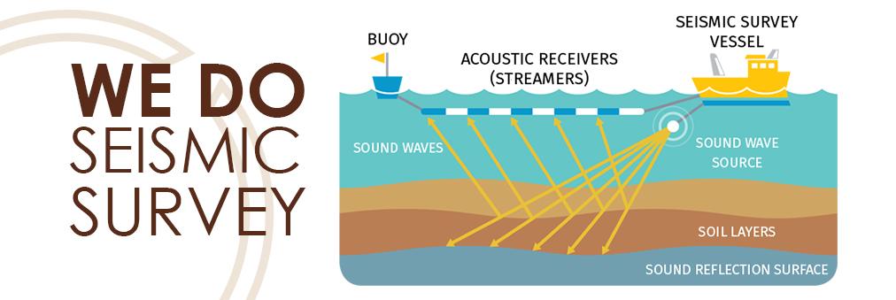
Subheading: Acquisition Technologies
To conduct a land seismic survey, geophones are carefully laid out in lines or grids over an area of interest on land. When an explosive charge or vibroseis truck generates the seismic waves, the geophones record the signals. For marine surveys, streamers towed behind survey vessels are used. These long cables contain geophones and electronics to measure and transmit the data to the ship in real-time. Air guns strategically fired in an array produce the seismic waves. Offshore surveys pose unique challenges due to rough water conditions but provide detailed images of geology below seabeds. New acquisition technologies such as wireless nodal recording systems and permanently installed bottom cable networks are enhancing both land and marine surveys.
Subheading: Processing and Imaging
The raw seismic data contains a complex mixture of reflected and scattered wave arrivals that must be deciphered. Sophisticated processing techniques are applied to enhance the signal and remove noise. Initial steps include correcting for instrument malfunctions and variations, eliminating surface reverberations and converting the measurements to units of pressure or particle velocity. Advanced processing may employ techniques such as deconvolution, velocity analysis, multiple elimination and migration to collapse diffractions and place reflections in their true subsurface locations. The end result is a seismic image depicting variations in rock properties with depth that reveal key geological structures. 3D surveys provide blocky volumes of subsurface data rather than just cross-sectional profiles.
Subheading: Applications in Oil and Gas Exploration
Seismic surveying plays a vital role in oil and gas exploration. After initial geological mapping and potential field surveys, seismic data provides detailed views of subsurface rock layers and structures that may trap hydrocarbons such as oil and natural gas. Reflection events corresponding to porous reservoir rocks like sandstone can be distinguished from impermeable cap rocks like shale. Structural features such as anticlines and fault traps become visible. With the processed seismic volume in hand, geologists interpret the data to delineate prospects and leads for further exploration drilling. At existing fields, time-lapse or 4D seismic monitoring between surveys tracks fluid movements for enhanced production strategies. The seismic method continues advancing to image ever deeper targets, quantify rock physics properties and help unlock challenging resource plays.
Subheading: Other Applications
Beyond hydrocarbon exploration, seismic surveying has broad interdisciplinary applications. Engineering projects require detailed information on soil and rock conditions beneath structures. Site surveys produce data to aid decisions on foundation designs for buildings, tunnels and bridges. Hydrogeological mapping employs seismic reflection and tomography to image aquifers and locate groundwater resources. Geologists use seismic images alongside other data to study tectonics, basins, volcanic systems and more. Passive seismic monitoring for tasks like 4D reservoir imaging or earthquake forecasting employ sensitive networks of geophones or hydrophones. Other emerging areas include carbon sequestration site characterization and monitoring, geothermal reservoir analysis and studies of crust and mantle properties using seismic waves from distant earthquakes. Overall, seismic methods continue expanding our 3D window into the dynamic planet below our feet.
Conclusion
Seismic technology has revolutionized knowledge of Earth's subsurface in the decades since its inception. Advanced acquisition systems combined with powerful computational processing unlock increasingly detailed views of geology. Applications extend from exploration for energy and mineral resources to engineering projects and fundamental earth science research. As techniques progress to image deeper targets, acquire denser data coverage and interpret a richer array of rock properties, seismic surveying remains on the cutting edge of non-invasive exploration. Its contributions to understanding Earth's complex interior and locating critical natural resources ensure seismic methods will continue evolving and enabling new scientific and economic frontiers in the decades to come.
Get more insights on this topic :
https://www.dailyprbulletin.com/seismic-surveys-a-cornerstone-technique-for-oil-and-gas-exploration/